OS1/10/11/11


| List of names as written | Various modes of spelling | Authorities for spelling | Situation | Description remarks |
|---|---|---|---|---|
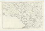
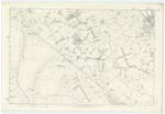
| LOCHAR WATER | Lochar Water Lochar Water Lochar Water Locher Water |
Singer's Agl. [Agricultural] Survey Fullarton;s Gazetteer Statistical Acc. [Account] of Dumfries Map of County |
049; 050; 056 | [Situation] On the N. E. [North East] and E. [East] Parish Boundary . A Rivulet formed by the Confluence of Amisfield and Park Burns. It traces the Eastern Parish Boundary of Dumfries cutting Lochar Moss into two nearly equal parts; - it in many parts of its Course resembles a Stagnant And vegetating pool, and previous to losing itself in the Solway Firth forms An estuary. - |
Continued entries/extra info
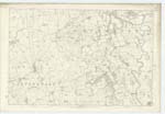
Parish of Dumfries -- Plan 49. 8. Trace No. 1 Supplementary -- [Page] 11.Authorities differ as to the Source of this Stream, some stating
it as rising in the Parish of KirKmahoe And others in the Parish
of Tinwald. - The Stream in KirKmahoe has been recognised as
Park Burn And as such is shewn on Plans and SKetch Maps as
tracing the boundary between that Parish and Tinwald, the latter
Stream in Tinwald is well Known in the locality by the name of
Amisfield Burn, - and as the great majority of the people in the district
State, - Lochar Water (proper) is only formed by the Confluence
of these two Streams near Lochar Briggs. - The only definite
authority which I can find is in the following quotations written by the
Minister in his Statistical Acc: [Account] of Parish of Tinwald "The Lochar commences near a
"small Village upon the Edinburgh Road called Jericho, where two rivulets of nearly the
"Same Size (the one forming for a Considerable space the western boundary of the Parish)
"join together, And afterwards Assume that name.- It separates the Parishes of Dumfries "
and Tinwald so far as they lie Contiguous."
[Signed] J B Junor
Transcribers who have contributed to this page.
Chr1smac -Moderator, Stoofer
Location information for this page.