OS1/10/10/1


| List of names as written | Various modes of spelling | Authorities for spelling | Situation | Description remarks |
|---|---|---|---|---|
| DRYFESDALE | Dryfesdale Dryfesdale Dryfesdale |
Johnston's Map of Dumfriesshire Crawford's Map of Dumfriesshire The New Statistical Account of D. [Dumfries] |
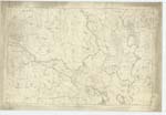
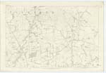
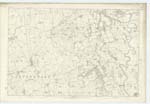
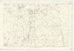
042; 043; 050; 051 | Forming a portion of N.E. district of Annandale in the County of Dumfries. The name of this Parish, as is obvious - is taken from the dale or valley of Dryfe which chiefly forms the district. The impetuosity or "driving" all before it when flooded is supposed to be alluded to in the name of this stream. |
Continued entries/extra info
The Parish of Dryfesdale is bounded on the North-West and North by that of Applegarth, on the East by the united Parishes of Hutton and Corrie, Tundergarth, and St. Mungo, - on the South by Dalton and on the West by Lochmaben. The North-Western and Northern boundaries are defined by Banks, Hodges, and Dryfe Water, on the East by Corrie and Milk Waters, small runners, hedges and banks, - on the South by River Annan and on the West by River Annan for the most part, drain, hedge and bank. – There is no detached part of Drfyesdale within the boundaries of another Parish, neither is there within its limits as above described a detached portion of any other Parish. From North to South its breadth gradually contracts from 4 ½ miles to chains – its length is upwards of 7 miles – its area may be computed at 11,000 Imp. [Imperial] Acres, of which 250 are wood, 350 moor and moss, and 10,400 arable and good pasture. The Northern and North-Eastern divisions are hilly – the south and Western districts may be considered flat, though at intervals considerable and in some instances abrupt acclimations occur. – The highest hill is Whitewoollen towards the North-eastern district, said to reach 1500’ above sea level. The other eminences do not exceed 600 feet, they are either under pasture or cultivation. The average rent of land – taking one acre with another – is about £1.1.11 – Farm-steadings have for the most part by indifferent accommodation, others, the land from improvements is fully enhanced to within the last twenty five years. – Small patches of peat-moss exist towards West side of Parish. – The only considerable stream within this Parish is Dryfe Water, which rises at the base of Loch Fell on the northern point of the Parish of Hutton and Corrie, and has altogether a run of 16 miles when it falls into River Annan at the N.W. side of this Parish, after a course of 9 ½ miles through this parish. – The River Annan washes the Parish on the West and South for 6 ½ miles, - the Corrie and Milk Waters also trace the S. and S.E. boundaries, numerous runners and springs water the district, one of the latter called Chapel Well from its proximity to the Ancient chapel at Beckton is reputed Chalybeate. – No minerals or ore have been found, and the district is without a freestone or other quarry, whinstone however is successfully wrought and supplies material for building. – Near Quaas ¼ mile East of Lockerbie there is a dark coloured limestone rock, which has however never been made use of. – Four Turnpike roads converge at the Northern extremity of Lockerbie, one to Annan runs South through the Parish for about 1 mile, another towards the great Carlisle road traverses S.E. a distance also of about 1 mile – the other two to or from Dumfries and to Moffat run S.W.W. and N.N.W. respectively for about 1 ½ mile. – the Parish generally enjoys excellent communication, and several handsome and substantial bridges convey the Turnpike and Parish roads across the various streams – one at Shillahill constructed of allendy [illegible] wood having seven arches was erected to the expense of the County in 1830. – the Glasgow and South-Western [Caledonian] Railway from the North-West side of Parish, runs for 2 ½ miles S.S.E. passing through the Town of Lockerbie where there is a commodious and well constructed station. – Lockerbie – lying midway between the Northeastern and South-eastern points of Parish is a [continued on next page]Transcribers who have contributed to this page.
Laurie Pasher, mikeh
Location information for this page.