OS1/10/9/62


| List of names as written | Various modes of spelling | Authorities for spelling | Situation | Description remarks |
|---|---|---|---|---|
| DORNOCK | Dornock | Walkers' Map of Scotland Crawford's Map of Dumfriesshire Johnston's Map of Dumfriesshire |
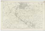
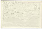
058; 063 | [Situation] Towards the S,En [South Eastern] point of the County of Dumfries The Name of this Parish is Compounded of Gaelic doire A wood And Cnoc - a hill. As the features of the district do not confirm this derivation probably Dornochel - the bare water is more descriptive. The Parish of Dornock is bounded on the North by those of Annan and Kirkpatrick-Fleming, on the East by Gretna, on the South by the Solway Firth and on the West by Annan. A portion of the Parish is detached which is bounded on the North, East and South by Kirkpatrick-Fleming and on the West by Annan, the Area of which being about 523 Acres. The Parish which nearly forms a Square, measures about 4 miles in length and 2 1/2 miles in breadth And its entire Area has now been computed at 5,779 Impl [Imperial] Acres 3/4 of which Are arable. The Soil in general is loam on brick earth, And though rather damp in winter is productive of luxuriant crops. The entire district is flat. The Coast along the Solway Firth is about 2 1/2 miles in extent and which is also low And sandy and wears altogether a monotonous aspect. Kirtle Water A Considerable Stream traces the Nn [Northern] boundary of the detached part of Parish, Dornock Burn a Considerable brook flows through the Centre of Parish, a few small rills from the interior contributing their waters thereto. No minerals are wrought in [Continued on page 63] |
Continued entries/extra info
[page] 62Parish of Dornock -- County of Dumfries
Transcribers who have contributed to this page.
Chr1smac -Moderator, Moira L- Moderator
Location information for this page.