OS1/10/7/104


| List of names as written | Various modes of spelling | Authorities for spelling | Situation | Description remarks |
|---|---|---|---|---|
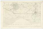
| SOLWAY FIRTH | Solway Firth Solway Firth Solway Firth Solway Frith Solway Frith Solway Frith |
New Statistical Account of Dumfriesshire Dr [Doctor] Singer's Agricultural Survey of Dumfriesshire Blackwood's County Map of Dumfries Walker's Map of Scotland Crawford's Map of Dumfriesshire Johnston's Map of Dumfriesshire |
062; 063; 066 | A very large bay projecting from the Irish Sea north-eastward between England and Scotland. - It bounds Cummertrees Ph. [Parish] on the South, - its width from shore to shore opposite this Parish being fully seven miles at full tides, but at ebb tides the only water in this part of the Firth is that of the Rivers Esk, Eden, and Annan, which run for upwards of a mile in one large and deep navigable channel. This Stream then separates suddenly, one part running along the English Coast and another along the Scotch, forming what is generally termed the English and Scotch channels. Firth is the colloquial term invariably applied here, which in such instances may be preferred to the word Frith, as the spelling thereof approaches nearer the derivative Norwegian Fiord - Latin fretum - a sea the root of the English term Frith. [initialled] JWJ |
Continued entries/extra info
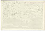
[page] 104Parish of Cummertrees -- Plan 62 No. 9 -- Trace 4
Transcribers who have contributed to this page.
Moira L- Moderator, SR1960
Location information for this page.