OS1/10/5/63


| List of names as written | Various modes of spelling | Authorities for spelling | Situation | Description remarks |
|---|---|---|---|---|
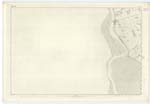
| CHANNEL OF THE RIVER NITH | River Nith River Nith River Nith River Nith River Nith Channel of the River Nith |
Bradshaw's Map of Great Britain B.F. Lloyd and Co.s [Counties] Map of England Black's Map of Scotland Mr. Bell of Saulls Mr. Wright of Bowhouse Park Six Inch Ord. [Ordnance] Map of Kirkcudbrightshire |
060 | [Situation] Forming and Tracing Nn. [Northern] Parish Boundary One of the principal rivers in the County of Dumfries, takes its rise in Ayrshire in the Parish of Dalmellington and runs Eastward into New Cumnock and enters the County off Dumfries at Carsoncone, near which the Glasgow and South Western Railway intersect the County and thence, running a winding course towards the South East receives in its passage many tributary streams as it passes by the town of Dumfries where it becomes navigable for small ships of 80, or 90, tons burden. About 2 1/2 miles below Dumfries it gradually expands into a small estuary, and between Burron point (sometimes called Carse point) in the Parish of Kirkbean and County of Kirkcudbright and Bow house Scar point in the parish of Carlaverock And near the venerable old ruins of Caerlaverock Castle it becomes lost in the Sands of the famous Solway Firth |
Continued entries/extra info
[Page] 63Parish of Carlaverock
Plan 60.12 Trace 2.3 -- 5.6
See Page 2
continued
Transcribers who have contributed to this page.
ADobie
Location information for this page.
Linked mapsheets.