OS1/10/3/82


| List of names as written | Various modes of spelling | Authorities for spelling | Situation | Description remarks |
|---|---|---|---|---|
| CUMSTONE BURN | Cumstone Burn Cumstone Burn Cumstone Burn Cumston |
Mr Little farmer Cumstone Mr Stewart farmer Gillenbie Mr Davidson shepherd Gillenbiehope Johnston's County Map |
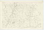
043 | [Situation] On En. [Eastern] Parish Boundary. A small brook which begins in Cumstone farm, from which it takes the name, runs in a Southward direction along the confines of this Ph. [Parish] and forms a confluence with Corrie Water. |
| BLACK RIG | Black Rig Black Rig Black Rig Black Rigg |
Mr Stewart farmer Gillenbie Mr Davidson Shepherd Gillenbiehope Mr Davidson overseer Balgray Mr A. Graham, farmer Hallhills |
043 | [Situation] 1/2 mile S.E. [South East] from firtree Hill. A long, bold elevated ridge of hill feature on the farm of Gillenbie. The soil a heathy pasture. Less than 1000 feet in altitude. |
Continued entries/extra info
[Page] 82Parish of Applegarth Plan 43.3 Trace 4
Transcribers who have contributed to this page.
DANIALSAN, E Henderson
Location information for this page.
Linked mapsheets.