OS1/10/3/58


| List of names as written | Various modes of spelling | Authorities for spelling | Situation | Description remarks |
|---|---|---|---|---|
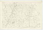
| CLEUCH-HEADS HILL | Cleugh-heads Hill | Peter Glover, Netherhall, Thomas Harkness, Gayfield, William Dickson, Sibblebieside |
043 | [Situation] 53 chains NE [North East] from Netherhall. A pretty high hill planted on the west and arable on the East sides. Situated on the farm of Cleugh-heads, and is the southern extremity of the western range of hills (mentioned in the Ph. [Parish] Statistics) which run from North to South through the Ph. [Parish] of Applegarth betwixt the River Annan and the Dryfe Water and at but a short distance from the latter. |
| CAMP [Cleuchheads Hill] | Roman Camp (Supposed) Roman Camp |
Parish Statistics William Dickson Sibblebieside Thomas Harkness Gayfield New Stat. Acct. [Statistical Account] of Applegarth |
043 | [Situation] On Cleuch-heads Hill Is situated on the summit of Cleugh-heads Hill, and on what is now planted. Its shape is nearly that of an oval, measures about 120 yards in length, by 70 yards in width, is surrounded by a single bank of earth, and still remains perfectly distinct. |
Continued entries/extra info
[Page] 58Parish of Applegarth Sheet 43.1 trace 1
[Signed] John Jane Sapper R.E. [Royal Engineers]
Transcribers who have contributed to this page.
DANIALSAN, E Henderson
Location information for this page.
Linked mapsheets.