OS1/10/3/1


| List of names as written | Various modes of spelling | Authorities for spelling | Situation | Description remarks |
|---|---|---|---|---|
| APPLEGARTH | Applegarth Applegarth Applegarth Applegarth or Applegirth |
Walkers' Map of Scotland Crawford's Map of Dumfries-shire Johnston's Map of Dumfries-shire New Gazetteer of Scotland |
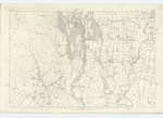
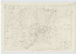
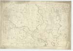
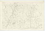
033; 034; 042; 043 | [Situation] Nearly in the Centre of the County of Dumfries. The Name of this Parish is compounded of Apple and Garth, the adjunct denoting in both Celtic and Gaelic - An enclosure. Applegarth is still the common appellation in Yorkshire for an Orchard. The Parish of Applegarth is bounded on the North by that of Wamphray, on the East by Hutton and Corrie, on the South by Dryfesdale and on the West by Johnstone and Lochmaben. There is no part of it within the boundaries of another Parish, nor is there within its limits a detached portion of any other Parish. Its greatest length from North to South is about 6 miles and its greatest breadth from West to East - in the Southern part of the Parish - is about 5 miles. Its Area has now been computed at 11,900 acres, of which 7,500 may be arable, 3,050 pasture, 200 wood and 150 irreclaimable land. The Soil is very productive. The entire district, with the exception of a portion of the Eastern and South-Eastern localities is flat. The high grounds lie on either side of Dryfe Water - the Wn [Western] range commencing nearly at the Southern point of Parish extends North till it joins the range of hills in Wamphray Parish, the other is a Continuation of that in Dryfesdale called Whitewoollen Hill which also runs North to Hutton and Corrie. The greatest elevation is Dinwoodie Hill near the N.Wn. [North Western] point of Parish which has an altitude of 736 feet above Sea level. The principal streams are the River Annan and Dryfe Water, the former separating this Parish from Johnstone and Lochmaben the latter crossing the S.En. [South Eastern] district and separating it from Dryfesdale. Various other minor streams all rising in the interior contribute their Waters to the foregoing. The Caledonian Railway from North to South intersects the Parish, and on which there is a small Station. The Country is entirely rural, no minerals are wrought nor manufactories carried on. There is no Market town, the principal village being Millhousebridge, - a small Collection of houses at the South-Western district. The great Turnpike Road from Glasgow to London via Carlisle runs from near the North-West point of Parish, S.S.E. [South South East] to the extent of five miles, from which a line diverges E.W. [East West] - There is one Parish Church which is inconveniently situated at the S.Wn. [South Western] extremity of the Parish. It was erected in 1760, Patrons Johnstone of Annandale and Sir William Jardine Bart. There are two Parish Schools. Jardine Hall at the West side of Parish is the principal Mansion. Population about 960. |
Continued entries/extra info
[Page] 1Parish of Applegarth, County of Dumfries
Transcribers who have contributed to this page.
DANIALSAN, E Henderson
Location information for this page.