OS1/7/2/49


| List of names as written | Various modes of spelling | Authorities for spelling | Situation | Description remarks |
|---|---|---|---|---|
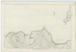
| ST JOHN'S POINT | St John's Point St John's Point St John's Point St John's or Mey Head |
Alexander Manson, Mey. Donald Shearer, Mey William Dunnet Mey |
002 | The extreme northern-most point of a small peninsula, of about 6 acres pasture land. on which in the days of Roman Catholicism Stood a Chapel at the South side. It appears from the still visible outline of a Fosse or ditch near the remains of the Chapel Slanting across longitudinally, meeting the Sea on both sides, that this headland was at one period completely severed from the main land - from such a Circumstance, it is highly probable that the buildings which at one time existed thereon were used as a means of defence against the aggressive pursuits of an enemy. - It is bounded by a cliff all around which reaches the height of 100 feet on the North Side. |
Continued entries/extra info
[Page] 49Parish of Canisbay -- Co [County] of Caithness
[Note] -- The principal headlands are
Grey-head, SKirsa-head, St John's or Mey head.
Transcribers who have contributed to this page.
Moira L- Moderator, Alexandra
Location information for this page.
Linked mapsheets.