OS1/6/6/14


| List of names as written | Various modes of spelling | Authorities for spelling | Situation | Description remarks |
|---|---|---|---|---|
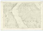
| RUDHA DUBH | Rue Dow Rue Dow Rue Dow Rue Du |
Estat Map Factor Mr. Crawford. Kilmichael Johnstone's Coy [County] Map |
193 | Rue Dow or the black point. a neck of land jutting into the sea, about a mile north of Kilmichael |
| OLD FERRY CRAIG | Old ferry Craig | Estate Map Factor Mr. Crawford. Kilmichael Johnstone's Coy [County] Map |
193 | A large high rock on the foreshore A ferry existed at one timeat this place the ruins of the Ferry House still remain. |
| LAMB CRAIG | Lamb Craig | Estate Map Mr. Crawford. Kilmichael Johnstone's Coy [County] Map |
193 | A large Craig on the foreshore a little to the N. W. [North West] of Kilmichael |
| CRETRIACH HILL | Cretriach Hill | Estate Map Factor Mr. Crawford. Kilmichael Johnstone's Coy [Couny] Map |
193 | A small rocky hill, a little to the east of old ferry craig, and beside the Altmore Burn |
| AULTMORE BURN | Aultmore Burn Aultmore Burn |
Estate Map Factor Mr. Crawford. Kilmichael Johnstone's Coy [County] Map Wilsons Guide to Bute |
193 | The Aultmore burn Commences at the Confluence of two streams, near the sheep fold or Ru on trace 7. And empties itself into the sea near the old ferry Craig |
Continued entries/extra info
[Page] 14County of Bute -- Parish of North Bute
Transcribers who have contributed to this page.
Dauvit- Moderator
Location information for this page.
Linked mapsheets.