OS1/4/17/21


| List of names as written | Various modes of spelling | Authorities for spelling | Situation | Description remarks |
|---|---|---|---|---|
| RIVER SPEY | River Spey R. [River] Spey Spey River Spey (The) Spey |
Estate Plan Mr John Fleming Factor Mr Alexander Grant Balnellan Blacks Map of Scotland Robertson's Map of Banffshire 1822 New Statistical Acoount. Fullarton's Gazetteer Old Statistical Account |
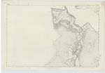
023 ; 029 | This river chiefly forms the boundary between the Counties of Banff and Elgin. At the part which runs through the Ph [Parish] of Inveravon it has changed its course on two occasions during heavy floods. It left the easternmost bed (as shewn on the traces of 23.11) in the year 1768 and from the centre bed it cut its way through the course it now follows in 1829. It is feared that if it reverts back to the first course it will destroy the church of Inveravon. The destruction of the church is fortold by Thomas the Ryhmer. This river rises in the braes of Badenoch in Inverness-shire and after a course of upwards of 100 miles it empties itself into the Moray Firth at Speymouth. There is no part of it navigable. |
Continued entries/extra info
Page 21Co [County] of Banff and Elgin -- Ph [Parish] of Inveravon
Transcribers who have contributed to this page.
Trondragirl- Moderator, Bizzy- Moderator, Bob Calder
Location information for this page.