OS1/2/74/4


| List of names as written | Various modes of spelling | Authorities for spelling | Situation | Description remarks |
|---|---|---|---|---|
| MULL | Mull | Imperial Gazeteer of Scotland Black's Map of Scotland Philips' County Atlas of Scotland |
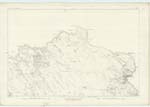
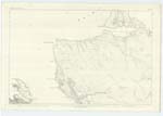
038 ; 039 | A large island in Argyllshire, and of all the Hebridean islands is third in magnitude. It is separated from the Scottish Mainland by the Sound of Mull on the N.E. [North East] ; on the E. [East] by the Firth of Lorn and is washed on all other sides by the Atlantic Ocean. So much is Mull indented by Bays and Marine Lochs that though measuring in extreme diameter not more than 35 miles it possesses a Circumference along sinuosities of its coast of upwards of 300 miles. Its greatest length w.s. westward from Duart Point opposite the southern expremity of Lismore to the small headlands on the Sound of Iona is about 30 miles. Its greatest breadth is a line from the northern extremity over the summit of Ben More to a point below the farm of Scorr in the Ross of Mull is about 25 miles. Mull may be summarily Characterized |
Continued entries/extra info
[Page] 4Argyllshire
[Note] Written on body of Sheets 83 & 84.
Transcribers who have contributed to this page.
Nora Edwards, BrenMRC
Location information for this page.