OS1/2/47/23


| List of names as written | Various modes of spelling | Authorities for spelling | Situation | Description remarks |
|---|---|---|---|---|
| EILEAN DUBH | Eilean Dubh | John Campbell Lochdonhead John McArthur Ardchoirk D McArthur Ardchoirk |
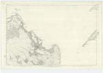
085 | Applied to an island situated at the head of Loch Don where Allt an Amair discharges itself into the Loch and a few chains north of Eilean Bàn. Sig: [Signification] Black Island |
| GLAC AN AMAIR | Glac an Amair | John Campbell Lochdonhead John McArthur Ardchoirk D. McArthur Ardchoirk |
085 | Applied to a small hollow situated immediately north of Lochdonhead and about 12 chains N.W. [North West] of Eilean Dubh |
| ALLT GLAC AN AMAIR | Allt Glac an Amair | John Campbell Lochdonhead John McArthur Ardchoirk D. McArthur Ardchoirk |
085 | A Stream, flowing in a South easterly direction into Loch Don and empties itself immediately E. [East] of Eilean Dubh. Sig: [Signification] "Stream of the hollow of the mill-dam" |
| STANDING STONE [Glac an Amair] | Standing Stone | John Campbell Lochdonhead John McArthur Ardchoirk D. McArthur Ardchoirk |
085 | A rough oblong stone, standing upright about 6 ft. [feet] high by 3 ft. [feet] broad, and 1 ft. [foot] thick; it is situate on rising ground about 1/2 a mile N. [North] of Lochdonhead, and is supposed to be a Druidical stone, but no authentic information can be obtained as to its origin. |
Continued entries/extra info
[Page] 23Sheet 85 Plan -- Ph. [Parish] of Torosay -- Island of Mull -- Argyllshire
[Page signed]
Alexander McDonald C.A. [Civilian Assistant]
Transcribers who have contributed to this page.
Alison James- Moderator, IanMcC, MullGenealogy
Location information for this page.
Linked mapsheets.