OS1/2/37/49


| List of names as written | Various modes of spelling | Authorities for spelling | Situation | Description remarks |
|---|---|---|---|---|
| NA GADAGAN | Na Gadagan Na Gadagan Na Gadagan |
John McGregor Camas Tuath Rev. [Reverend] A. Campbell, Bunessan Duncan McKenzie, teacher, Bunessan |
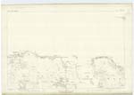
105 | A narrow strip of wooded hillside situated on the east side of Beinn Chladan, and south east of Braigh Craobhach. Sig: [Signification] The Withes. |
| BEINN CHLÀDAN | Bein Chlàdan | John McGregor Camas Tuath Rev. [Reverend] A. Campbell, Bunessan Duncan McKenzie, teacher, Bunessan |
105 | A rocky hill situated west of Na Gadagan, and on the north side of the road leading from Bunessan to Iona ferry. Sig: [Signification] Mountain of Flakes. |
| BRÀIGH CRAOBHACH | Bràigh Craobhach | John McGregor Camas Tuath Rev. [Reverend] A. Campbell, Bunessan Duncan McKenzie, teacher, Bunessan |
105 | Applied to a wooded hillside situated north of Beinn Chladan and north west of Na Gadagan. Sig: [Signification] Woody Brae. |
Continued entries/extra info
[Page] 49Sheet 105. Plan 14 -- Island of Mull -- County of Argyll
[Page signed]
T. McLean Sapper R.E. [Royal Engineers]
Transcribers who have contributed to this page.
Alison James- Moderator, hillhere
Location information for this page.
Linked mapsheets.