OS1/2/34/2


| List of names as written | Various modes of spelling | Authorities for spelling | Situation | Description remarks |
|---|---|---|---|---|
| AM BURG | Am Burg Am Burg |
Mr Donald Johnson, Mason, Machir Mr William Torrie, Teacher, Port Charlotte Rev John McGilchrist Bowmore |
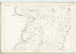
207 | A rocky point of land nearly surrounded by a precipice, and separated from the mainland on the north and south by a creek. Situated a quarter of a mile north of Coul Point. Meaning "The Tower or Fortress" - The property of the Trustees of the late Mr Mclean of Foreland Ho [House]. |
| GEODHA NAN LEAC DUBHA | Geodha nan Leac Dubha | Mr Donald Johnson, Mason, Machir Mr William Torrie, Teacher, Port Charlotte Rev John McGilchrist Bowmore |
207 | A creek on the sea coast south of Am Burg. Meaning "Black Flags' Creek". |
| GEODH' A' BHUIRG | Geodh' a' Bhuirg Geodh' a' Bhuirg |
Mr Donald Johnson, Mason, Machir Mr William Torrie, Teacher, Port Charlotte Rev John McGilchrist Bowmore |
207 | A creek on the north side of Am Burg. Meaning "Creek of the Tower or Fortress". |
| GEODHA NAM MULT | Geodha nam Mult | Mr Donald Johnson, Mason, Machir Mr William Torrie, Teacher, Port Charlotte Rev John McGilchrist Bowmore |
207 | A creek on the coast a short distance north of Am Burg. Meaning "Wedders' Creek". |
Continued entries/extra info
2 [left corner of header]Island of Islay [in header]
Sheet 207. Plan 1 Parish of Kilchoman - Argyllshire [in header]
Sheet 207 Plan 1 trace 3 [Situation for Am Burg]
Sheet 207 Plan 1 trace 3 [Situation for Geodh nan Leac Dubha]
Sheet 207 Plan 1 trace 3 [Situation for Geodh' a' Bhuirg]
Sheet 207 Plan 1 trace 3 [Situation for Geodha nam Mult]
Transcribers who have contributed to this page.
JCB
Location information for this page.
Linked mapsheets.