OS1/1/42/36


| List of names as written | Various modes of spelling | Authorities for spelling | Situation | Description remarks |
|---|---|---|---|---|
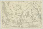
| Site of ROMAN ROAD | (Site of) Roman Road (Site of) Roman Road (Site of) Roman Road |
Revd. [Reverend] Mr. Davidson, Inverury Mr William Johnston, Brandsbutt Mr William Matheson, Netherton |
054 | This road leaving the parish of Kintore crossed the Don at How Ford, and entering the village of Inverurie at the south end of High Street followed this street as far as the Post Office. Changing its direction to the north west here, it ran straight to the Lanyard where the Burgh Muir joins the High Street, cutting a small portion from the bend of the street near the Town Hall. Following the present line of road through the Burgh Muir for 150 yards it again changed its direction to the northwest, and skirting the southwestern edge of the Market Stance caught the old road leading from it to Stonefield Croft, situated south of Brandsbutt. This old road is said to be the remains of the Roman Road. From Stonefield Croft it led up through the present arable fields to a long straight stone wall running north-west from Brandsbutt farmsteading. Following this line of wall it Kept almost the same direction to the smithy on the Chapel of Garioch road near Balquhain Castle. From thence this road marks its site as far as the parish boundary. Near a croft on the farm of Netherton and close to the end of the long stone wall it was joined by the old Aberdeen and Garioch road. No trace of a Camp is to be seen on this line of road, but the Revd. [Reverend] Mr Davidson, who supplied this information is of the opinion that a Roman Camp exists on the estate of Chrichie in the Parish of Kintore. |
| OLD ROAD | For 1" [1 inch] purposes only. See Remark in Index. 1895 | Mr. James Macdonald, The Farm, Huntly N.B. [North Britain] |
Continued entries/extra info
[Page] 36Parish of Inverury
Transcribers who have contributed to this page.
Kate51- Moderator, Geoffrey M Gill
Location information for this page.
Linked mapsheets.