
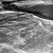
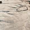
Heriot's Dyke


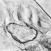
Harefaulds, settlement and cultivation remains: oblique air photograph.
(Also shows Heriot's Dyke, linear earthwork).
View in Canmore
View in Canmore

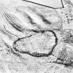
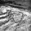
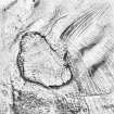
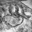
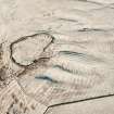
Oblique aerial view of Harefaulds centred on the remains of the fort, settlement and cultivation remains, taken from the NW.
View in Canmore
View in Canmore

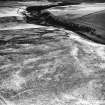
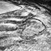
Oblique aerial view of Harefaulds centred on the remains of the fort, settlement, linear earthwork and cultivation remains, taken from the ENE.
View in Canmore
View in Canmore

Harefaulds, settlement and cultivation remains: oblique air photograph.
(Also shows Heriot's Dyke, linear earthwork).
View in Canmore
View in Canmore

Oblique aerial view of Harefaulds centred on the remains of the fort, settlement and cultivation remains, taken from the W.
View in Canmore
View in Canmore

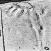
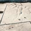
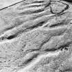
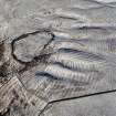
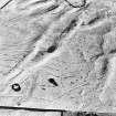
Oblique aerial view of Harefaulds centred on field system and small cairns, taken from the NE.
View in Canmore
View in Canmore

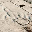
Harefaulds, settlement and cultivation remains: oblique air photograph.
(Also shows Heriot's Dyke, linear earthwork).
View in Canmore
View in Canmore

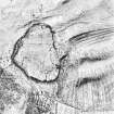
Oblique aerial view of Harefaulds centred on the remains of the fort, settlement and cultivation remains, taken from the SSW.
View in Canmore
View in Canmore

Oblique aerial view of Harefaulds centred on field system and small cairns, taken from the ENE.
(Also shows Heriot's Dyke, linear earthwork).
View in Canmore
View in Canmore

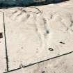
Harefaulds, settlement and cultivation remains: oblique air photograph.
(Also shows Heriot's Dyke, linear earthwork).
View in Canmore
View in Canmore

Harefaulds, settlement and cultivation remains: oblique air photograph.
(Also shows Heriot's Dyke, linear earthwork).
View in Canmore
View in Canmore

Oblique aerial view of Harefaulds centred on the remains of the fort, settlement, linear earthwork and cultivation remains, taken from the N.
View in Canmore
View in Canmore

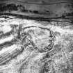
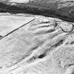
Oblique aerial view of Harefaulds fort, settlement and cultivation remains with Heriot's Dyke earthwork, taken from the SSE.
View in Canmore
View in Canmore

Oblique aerial view of Harefaulds centred on the remains of the fort, settlement and cultivation remains, taken from the SW.
View in Canmore
View in Canmore

Heritos Dyke, NT55SE 24, Ordnance Survey index card, Recto
View in Canmore
View in Canmore

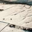
Oblique aerial view of Harefaulds centred on cultivation remains, a field-system, small cairns and a linear earthwork, taken from the NE.
View in Canmore
View in Canmore

Oblique aerial view of Harefaulds centred on the remains of the fort, settlement, linear earthwork and cultivation remains, taken from the N.
View in Canmore
View in Canmore

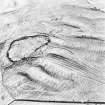
Oblique aerial view of Harefaulds centred on field system and small cairns, taken from the WNW.
View in Canmore
View in Canmore

Oblique aerial view of Harefaulds centred on field system and small cairns, taken from the NNE.
(Also shows Heriot's Dyke, linear earthwork).
View in Canmore
View in Canmore

Harefaulds, settlement and cultivation remains: oblique air photograph.
(Also shows Heriot's Dyke, linear earthwork).
View in Canmore
View in Canmore

Oblique aerial view of Harefaulds centred on the remains of the fort, settlement and cultivation remains, taken from the SE.
View in Canmore
View in Canmore

Oblique aerial view of Harefaulds centred on field system and small cairns, taken from the NNE.
View in Canmore
View in Canmore

Oblique aerial view of Harefaulds fort, settlement and cultivation remains with Heriot's Dyke earthwork, taken from the SSE.
View in Canmore
View in Canmore

You may copy, display, store and make derivative works for personal use or use solely within an educational institution by staff and students, under these conditions: the ScotlandsPlaces website is attributed, there is no commercial use or sale, and no public distribution (for example, by hand, email, or web). Full licence details.
Details
Organisation: Historic Environment Scotland (HES)
Alternative name(s):
Canmore ID: 56000
Site type: Linear Earthwork (period Unassigned)
County: Berwickshire
Parish: Lauder
Council: Scottish Borders, The