OS1/24/41/85


| List of names as written | Various modes of spelling | Authorities for spelling | Situation | Description remarks |
|---|---|---|---|---|
| DAMHEAD SHIEL | Damhead Shiel Damheadshiel Damhead Shield Damhead Shield |
Andrew Weatherstone Campshiel Archibald Reid, Damheadshiel Johnston's Co. [County] Map Armstrong's Co. [County] Map |
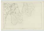
018 | [Situation] About ¼ of A Mile N.W. [North West] of Camp Shiel A one Storey Slated dwelling-house, with office-house And garden Attached. It is in good repair - inhabited by a Shepherd - And is Situated on the farm of Damhead, near the Fingland Burn. |
| FINGLAND BURN | Fingland Burn | Andrew Weatherstone Campshiel Archibald Reid, Damheadshiel |
[Situation] Flows about ¾ of A Mile S.W. [South West] of White Rig A Considerable Water having its rise in the County of Selkirk - And running betwixt the Southerly parts of Traquair Knowe & Damhead farms, and past Campshiel, Damheadshiel, And Damhead, Crosses the public Road and falls into the Quair. |
|
| CAMP SHIEL | CampShiel Campshiel |
Andrew Weatherstone Campshiel Archibald Reid, Damheadshiel |
018 | [Situation] About ⅝ of A Mile N.W. [North West] of White Rig A one Storey thatched dwelling house, with Office-house And garden Attached. It is in good repair - is inhabited by a shepherd - And is Situated on the farm of Traquair Knowe, near the junction of Campshiel Burn with Fingland Burn. |
Continued entries/extra info
[Page] 85Parish of Traquair - Sheet 18 No 10 Trace 1
Transcribers who have contributed to this page.
JOANMUIR
Location information for this page.
Linked mapsheets.