OS1/23/16/6


| List of names as written | Various modes of spelling | Authorities for spelling | Situation | Description remarks |
|---|---|---|---|---|
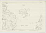
| GEO OF THE DYKE-END | Geo of the Dyke End | Hugh Craigie, Wasbister Mr Cooper Teacher Wasbister Mr I. I. Inkster Sourin |
084 | Applies to a creek on the coast with perpendicular rocks situate 20 chains wast of Horse Brae |
| HORSE BRAE | Horse Brae | Hugh Craigie, Wasbister Mr Cooper Teacher Wasbister Mr I. I. Inkster Sourin |
084 | Applies to a ridge of land covered with rough pasture situate 20 ch S.E. from "Sacquoy Head" & 15 ch S.W. from "Stenchna Geo" |
| WESTRAY FIRTH | Westray Firth | Hugh Craigie, Wasbister Mr Cooper Teacher Wasbister Mr I. I. Inkster Sourin Orkney Directory |
084; 096 | This firth is formed by the Island of Westray, Fara & Eday to the north-eastward & Rousay & Egilshay to the south-westward; it is about 10 miles long & 2 1/2 miles in average width |
Continued entries/extra info
Below Westray Firth: (Roman Capitals) Typed on body of Sheet 85.11The whole of the names on this 'name sheet' are on the property of Col Burroughs C.B. Rousay, Orkney
Transcribers who have contributed to this page.
Muriel Rousay
Location information for this page.