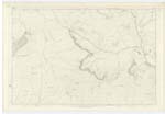
OS1/14/46/39


| List of names as written | Various modes of spelling | Authorities for spelling | Situation | Description remarks |
|---|---|---|---|---|
| MONAMEANACH | "Monadh Meadhonach" "Monadh Meadhonach" Monamenoch Mealnamennoch Monameanach |
John Robertson James Stewart Charles Duncan, "Linns" Estate Map and Earl of Airlie Proprietor Johnson's County Map A. W. Myles Esq. Forfar |
015 | A prominent Hill on the west side of the parish; it is ranked among those of the highest in this quarter. - The name is essentially Gaelic. |
| MID STRONE | Mid Strone | John Robertson James Stewart Charles Duncan, "Linns" Estate Map |
010; 015 | A feature forming part of the hill above described. |
| CNOCANDON | "Cnocandon" "Cnocandon" Crockenjon |
John Robertson James Stewart Estate Map |
015 | A small rocky feature a little to the north of Auchavan, - Being of origin, the name is intended for the "Devil's Knoll". |
Continued entries/extra info
[Page] 39Glenisla Parish -- Forfarshire
Monameanach [note]
"The Central Mountain" (G [Gaelic])
[partly overwritten] between
Glas Maol and Mount Blair.
Transcribers who have contributed to this page.
Alison James- Moderator, Alice Bremner
Location information for this page.