System Outage
We are migrating the servers that support this website to a new platform. Service will be affected for some time. Further information is available here.
OS1/14/16/13


| List of names as written | Various modes of spelling | Authorities for spelling | Situation | Description remarks |
|---|---|---|---|---|
| MONTROSE BASIN | Montrose Basin Montrose Basin Montrose Basin Montrose Basin Montrose Basin Montrose Basin Montrose Basin Montrose Basin Montrose Basin Montrose Basin Montrose Basin |
Montrose Bridge Acts Estate Maps Mr. Macdonald Macdonald of Rossie Mr. Burness, Wr. [Works] Clerk, Mont Br. [Montrose Bridge] Mr Myers Town Clerk Revd. [Reverend] Mr. Mitchell, F.C. [Free Church] Revd. [Reverend] Mr Mitchell, Ph. [Parish] of Craig Fullarton's Gazetteer New Statistical Account Old Statistical Account Memorials of Angus & Mearns |
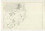
035 | An extensive and natural Basin connected with the sea, & having the South Esk flowing through it on its south side. It extends to the Parishes of Dun, Montrose & Maryton, besides Craig. At Low Water the general character of the bottom is blue clay softened on the surface like a muddy sand, which is the proper description, the Sand being caused by the washing over of the Tides. In some parts there is Mud to the depth of 6 feet ax [approximately] upon the Mussel Bed in this Parish. Sand is to be seen in Dun Ph. [Parish] particularly where it marches with Craig & Montrose at the mouth of Tayock Burn. [continued on page 14] |
Continued entries/extra info
[Page] 13Co. [County] Forfar -- Craig Parish
[Note]
"The Basin forms particularly at
full tides, one of the grandest
natural objects of which any town
in the Kingdom can boast, being
a fine sheet of Water, nearly Circular,
and about 3 miles in diameter"
Jervise's Memorials
Transcribers who have contributed to this page.
Alison James- Moderator, Caspell
Location information for this page.
Linked mapsheets.