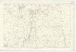
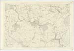
OS1/10/45/49


| List of names as written | Various modes of spelling | Authorities for spelling | Situation | Description remarks |
|---|---|---|---|---|
| RIVER ANNAN | River Annan River Annan River Annan |
Blackwoods C. [County] Map Robert McGregor Henry Irvin Bell |
051; 057 | [Situation] On the Sn. [Southern] Parish Boundary. A large River having its source in the parish of Moffat, It flows in a Southerly direction and falls into the Solway Firth South from Annan |
| ST. MUNGO FORD | St. Mungo Ford | See Dalton Name Book Page 46 | 057 | |
| ST MUNGO'S CHURCH (Remains of) | St. Mungo Church (remains of) St. Mungo Church (remains of) St. Mungo Church (remains of) |
Robert McGregor Henry Irvin Bell Walter Cowan |
057 | [Situation] About 1¼ miles S.W. [South West] fromKettlebridge The site or remains of what was formerly a place of worship. |
| COTTAGE ISLAND | Cottage Island | See Dalton Name Book Page 46 | 057 | |
| SORRYSIKE MOOR | Sorreysyke Moor Sorreysyke Moor Sorreysyke Moor Sorrysike Moor Sorrysike Moor Souriesike Moor |
Robert McGregor Henry Irvin Bell Walter Cowan Statistics of St. Mungo Valuation Roll Genl. [General] Roy's Map of Lower Annandale |
057 | [Situation] About 1¾ mile S.S.W. [South South West] from Kettlebridge. A small tract of moorland on Milk Bank Estate, |
| SHIEL BURN | Shiel Burn | See Page 35 | 051; 057 |
Continued entries/extra info
[Page] 49Parish of St. Mungo Plan 57-1
Samuel S Hill
Lce. Corpel. RSM [Lance Corporal Royal Sappers and Miners]
Transcribers who have contributed to this page.
DANIALSAN, mikeh
Location information for this page.