OS1/10/6/59


| List of names as written | Various modes of spelling | Authorities for spelling | Situation | Description remarks |
|---|---|---|---|---|
| KENRIVA BURN | Kenriva Burn Kenriva Burn Kenriva Burn Kenriva Burn Kenriva Burn |
Adam Menzies Shepherd, Garroch Andrew Hunter Andrew Jardine Shepherd Burleywhag Johnston's County Map Buccleuch Estate Map, Feby [February] 1857, |
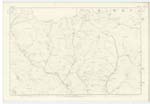
023 | [Situation] From Gana Hill S. [South] to Garroch Water A Stream which takes its rise a little East of the Gauney, flows South and Joins Garrock water, both united form Clachope Water, |
| BUGHT CLEUCH | Bught Cleugh Bught Cleugh Bught Cleugh |
Adam Menzies Andrew Hunter Andrew Jarden |
023 | [Situation] 1/2 mile N E, [North East] from Garroch, A hollow or glen through which a stream flows it rises near the Haggie Hill and falls into Kinriva burn |
| GARROCH | Garroch Garroch Garroch Garroch |
Adam Menzies Andrew Hunter Andrew Jarden Estate Maps and Documents of the Duke of Buccleuch |
023 | [Situation] At the w, [west] side of this Plan, Two Cottages with garden attached the property of the Duke of Buccleuch |
Continued entries/extra info
[page] 59Parish of Closeburn -- Plan 23/10 -- Trace 1
[signed] William Wright c/a [Civilian Assistant]
Transcribers who have contributed to this page.
Chr1smac -Moderator, Moira L- Moderator
Location information for this page.
Linked mapsheets.