OS1/5/1/8


| List of names as written | Various modes of spelling | Authorities for spelling | Situation | Description remarks |
|---|---|---|---|---|
| LAMMERMOOR HILLS | Gazetteer of Scotland Map of Scotland New Statistical Account |
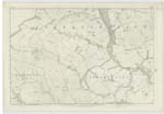
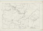
004 ; 010 | A broad range of moorish heights stretching eastward from the Vale of Gala Water - in the S. E. [South East] extremity of Mid-lothian to the German ocean at the promontories of Fast Castle, Ernscleugh, and St. Abb's Head in the Parish of Coldingham Berwickshire The Lammermoors all lie within East Lothian and Berwickshire, commencing at their extreme Western limit forming for two thirds of their extent a southern screen, or belt of uplands to Mid Lothian, & constituting of the Lammermoor part of Lauderdale be included, nearly one half of Berwickshire. The Lammermoors are, in themselves are extensive curvature of, for the most part, wild, cheerless, unsightly heights - no where bold & imposing in aspect & often subsiding into low rolling table lands of bleak moor. They were at one period clothed with Forest & must then have been as bewildering to the traveller as grandly sylvan in their vast contributions to the landscape - they still have natural woods hanging on some of their steeps and in such localities are warmed out of their chilliness of aspect - but over their summits & down their higher slopes, they are almost every where nakedly dressed in heath. Lammerlaw which lies in the parish of Lauder & gives name to the whole range has an altitude of 1,500 feet - Griblaw 1.615 feet - Clinthill 1.544 - Tippetknowes 1.323 -Mauslaughter Law 1.273. Twinlawhill 1.260 - Earlstonhill 1.200 -Great Dirringtonlaw 1.145 Ayrehouse Hill 1054. Bemersidehill 1.011 - & Cockburnlaw 912 feet Gazatteer of Scotland page 206 R Thornaby ap: NR 14 July 1856 |
Continued entries/extra info
[Page] 8Parish of Abbey St Bathans Detached
W. Beatty
Transcribers who have contributed to this page.
Moira L- Moderator, DANIALSAN, DiSaxton, Pookarogue
Location information for this page.