OS1/35/68/6


| List of names as written | Various modes of spelling | Authorities for spelling | Situation | Description remarks |
|---|---|---|---|---|
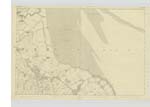
| WIGTOWN BAY | Wigtown Bay Wigtown Bay |
J. McHaffie, Esq. Mr. J. Muir. |
026 | [Situation] - At S.E. [South East] of Wigtownshire forming in part the boundary between Wigtownshire & Kirkcudbrightshire.- A large bay or estuary at the S.E. [South East] side of Wigtownshire at the influx of the River Cree and Bladenoch with the Sea. It runs inland a distance of about 10 miles till it terminates in the Cree gradually varying in breath. Its greatest breadth from Garlieston Bay or [Crugleton] to the point of Ross is 10 mile. Its depth is various generally between 20 & 30 feet deep. The most important harbours or [landing] places in 'this bay' is Carty, [Wigtown], and Garlieston. See Statisl . Acct. [Statistical Account] of Scotland Published 1841. |
Continued entries/extra info
[Page] 6 - Parish of KirkinnerTranscribers who have contributed to this page.
Chr1smac -Moderator, Muriel Rousay
Location information for this page.
Linked mapsheets.