OS1/35/68/15


| List of names as written | Various modes of spelling | Authorities for spelling | Situation | Description remarks |
|---|---|---|---|---|
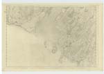
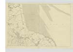
| HEUGHS OF BARHOLM | Heughs of Barholme. Heughs of Barholme. Heughs of Barholme. Barholme. |
Alexander McKean. James McKean. Robert Jardine. Ainslies Map of 1783. |
026 | [Situation] - From 1/4 to 1/2 mile S by E [South by East] of Kirkdale Bridge. A range of Steep precipices in Some parts covered with oak and underwood, its base forms the high water mark of Spring tides. |
| RAVENSHALL POINT | Ravenshall Point. Ravenshall Point. |
James Cairns. Alexander McKean. |
048; 049; 026 | [Situation] - 1/2 mile S by E [South by East] of Kirkdale Bridge. A Small rocky promontory formed by the Southern extremity of the Heughs of Barholme and named after the farm on which it is situate. |
| WHITE HILL | White Hill White Hill |
Charles Rankin. William Parker. |
026 | [Situation] - 1 3/4 miles WNW [West North West] of Kirkdale House. A Small hill on the farm of Carsluith. |
Continued entries/extra info
[Page] 15-- Parish of Kirkmabreck[Barholme] - "See Spelling of this name in Name book Plan 48 A Kirkcudbrightshire "
[White Hill] - " See Name Book for Plan 48A Kirkcudbrightshire. "
Transcribers who have contributed to this page.
Chr1smac -Moderator, Muriel Rousay
Location information for this page.