OS1/35/35/67


| List of names as written | Various modes of spelling | Authorities for spelling | Situation | Description remarks |
|---|---|---|---|---|
| CLENNOCH HILL | Clenoch Hill Clennoch Hill Clannoch Hill |
John Adair Esqr. James Covin Ainslie's Map 1782 |
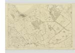
016 | [Situation] At the S.E. [South East] Side of the town of Stranraer A Small well cultivated hill or eminence on the lands of Clennoch on which is a Trigl. [Trigonometrical] Station improperly Called "Glennlock Hill" by Trigl. [Trigonometrical] Party |
| BLACK STANK | Black Stank Black Stank |
James Stewart John Crawford |
016 | [Situation] Passing through the S.W. [South West] corner of the Parish of Inch near the E. [East] Side of Stranraer A Considerable burn or Stream chiefly formed of three tributary Streams are running out of Chapman Loch in Culhorn Demesne another from the west Side of Culroach and a 3rd from a moss in Culmuck close to the march of the farm of Barnultach & running in a northerly direction it is Known by the name Black Stank as for north as Aird Bridge after which it is Called Bishop Burn |
| BISHOP BURN | Bishop Burn Bishop Burn |
James Stewart John Crawford |
016 | [Situation] The continution of Black StanK from Aird Bridge to its influx with Loch Ryan 7/8 of a mile E N E [East North East] from the North West Castle This Burn is the Continuation of the Black Stank from Aird Bridge to Lochryan |
Continued entries/extra info
Parish of Inch -- [Page] 67"StanK" a pool or pond Dr. Jamieson's Dictionary
Transcribers who have contributed to this page.
Chr1smac -Moderator
Location information for this page.
Linked mapsheets.