OS1/28/51/64


| List of names as written | Various modes of spelling | Authorities for spelling | Situation | Description remarks |
|---|---|---|---|---|
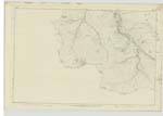
| GENERAL WADE'S MILITARY ROAD | General Wade's Military Road | Mr McRae, Clunie Inn Mr Grant, Tomdoun Inn |
131; 132; 133 | This old road, called after its maker, through neglect is in many places untraceable. It passes through Glen Clunie and Glen Shiel from Fort George to Glenelg where there was a military station last century. |
Continued entries/extra info
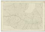
[Page] 64Ross-shire -- Parish of Glenshiel
This road enters the County of Ross at the boundary, about a 1/4 mile N. [North] of Loch Clunie, and is in fair order up to a stream 1/4 mile E. [East] of "Drochaid Coill' a' Chait - from which bridge it is not recognisable - until about 10 chains W. [West] of "Drochaid Allt a' Chaoruinn Mhòir" when it branches off the Parliamentary Road and runs parralel to the same until it joins the same Road about 1/4 m [mile] W. [West] of the bridge named "Drochaid Allt a' Chaoruinn Bhig" from which point it is not traceable until about 10 chains S. [South] of "Clunie Inn" when it branches off the Main Road, and runs parralel to the same for about 2 miles and joins the said road 10 chains S.E. [South East] of 2 1/2 m [mile] stone from Clunie Inn from which point it is undefined until it branches off the Parliamentary Road again at a Sheepfold about 1/4 mile E. [East] of the M.S. [Mile Stone] marked Clunie Inn 4 1/2. it running parralel to the said road for one mile - when it joins the said road at the 5 1/2 M.S. [Mile Stone] from Clunie Inn, from which point it becomes undefined until it again branches off the road at the bridge named "Drochaid Beul-ath-Chapain" when it runs in an irregular manner for about 2 miles.
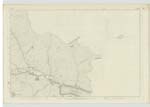
See Name Book for Sheet 138. for further description.
Transcribers who have contributed to this page.
Bizzy- Moderator, angusb
Location information for this page.
Linked mapsheets.