OS1/27/8/30


| List of names as written | Various modes of spelling | Authorities for spelling | Situation | Description remarks |
|---|---|---|---|---|
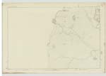
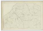
| GLEANN RUADH | Gleann Ruadh | Donald MacDonald Shader Informant could not spell John Morrison Ordnance Survey |
005 | This is a Glen on both Sides of Amhuinn a Ghlinne Ruaidh its Surface is partly broken producing very bad mossy pasture on the Margins of the river there is a small patch of green or arable pasture belonging to the Glen the rest is very bad pasture &c Situated and extending east from the junction of Amhuinn Bhuirgh to Amhuinn Cuig Peghinnean and Amhuinn a Ghlinne Ruaidh and along both sides of the later as far as Dunaclaid |
| AMHUINN A GHLINNE RUAIDH | Amhuinn a Ghlinne Ruaidh | Donald MacDonald Shader Informant could not spell John Morrison Ordnance Survey |
005 | This is a river which flows from the north side of Mulachan through Gleann Ruadh till it falls into or joins Amhuinn Cuig Peghinnean at the junction of Amhuinn Bhuirgh |
| TOM STRIAMRABHAT | Tom Striamrabhat | Donald MacDonald Shader Informant could not spell John Morrison Ordnance Survey |
005 | This is a small low conical knoll on the top of which is a trig [trigonometrical] station its surface is very much broken and producing very indifferent mossy pasture &c Situated about 50 Cahins north east of Gleann Ruadh &c |
Continued entries/extra info
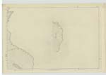
[Page] 30Plan 5 D Trace No. 1 -- List of Names collected by Thomas O'Farrell C.A. [Civilian Assistant]
Parish of Barvass
Objects
Gleann Ruadh - Glen
Amhuinn a Ghlinne Ruaidh - River
Tom Striamrabhat - Knoll
[Page signed]
Thomas O'Farrell
4th. March
Transcriber's notes
TOM NA STRIAMRABHAT - although the sheet number is correct, the place name was omitted by the cartographers from the 1st edition sheet map due to a lack of space on the sheet.However, note on page 4 indicates that this entry has been struck out completely.
Transcribers who have contributed to this page.
Alison James- Moderator
Location information for this page.