OS1/27/5/69


| List of names as written | Various modes of spelling | Authorities for spelling | Situation | Description remarks |
|---|---|---|---|---|
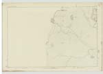
| GEODHA GHÒRM | Geodha Ghòrm | Donald Nicholson Melbost Informant could not Spell John Morrison Ordce [Ordnance] Survey |
005 | This is a Small narrow Shallow Creek or indentation on the Sea Shore with a Small Cliff around it adjacent to which is a trig [trigonometrical] Station Situated adjacent to and north east of Geodha na Faing. |
| BREIBHIG | Breibhig | Donald Nicholson Melbost Informant could not Spell John Morrison Ordce [Ordnance] Survey |
005 | This is a beach composed of Shelving rocK which is low and flat between High and Low water marks about 8 chains wide by 20 long Situated adjacent to and north east of Geodha Ghorm. |
| SGEIR IASGAIN | Sgeir Iasgain | Donald Nicholson Melbost Informant could not Spell John Morrison Ordce [Ordnance] Survey |
005 | This is a rock connected with the Shore at low water mark or rather a point on the margin of Low water which is visible till about half tide Situated adjacent to and north east of Breibhig. |
Continued entries/extra info
[page] 69Plan 5A -- List of Names collected by Thomas O Farrell CA [Civilian Assistant]
Trace 2
Township or Parish - Barvas
Objects
Geodha Ghòrm - CreeK
Breibhig - RocK
Sgeir Iasgain - RocK
[signed] Thomas O Farrell ca [civilian assistant]
1st March 1852
Transcribers who have contributed to this page.
Bizzy- Moderator, eilthireach
Location information for this page.