OS1/27/2/94


| List of names as written | Various modes of spelling | Authorities for spelling | Situation | Description remarks |
|---|---|---|---|---|
| AIRD SGEIGANIS | Aird Sgeiganis | John Morison Cnoc Ard Informant could not spell John Morrison Ordce [Ordnance] Survey |
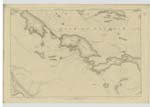
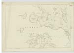
003 | This is a small low head land forming a tall hill which is partly arable and partly mossy pasture its coastline is rough and uneven there are two trig [trigonometrical] Stations on its Summit Situated about a mile South of Ness Port. |
| SRON BIREDONNACHAIS | Sron Biredonnachais | John Morison Cnoc Ard Informant could not spell John Morrison Ordce [Ordnance] Survey |
003 | This is a bold prominent point of Shore which forms the most easterly point of Ard Sgeiganis there is an accessable Cliff over it there is little or no beach See[n] at it. |
| GEODH' A BHAIRD | Geodh a Bhaird | John Morison Cnoc Ard Informant could not spell John Morrison Ordce [Ordnance] Survey |
003 | This is a Small deep narrow creek or indentation on the Sea Shore over which is a Steep but accessable Rocky Cliff Situated on the north east Shore of Ard Sgeiganis. |
Continued entries/extra info
[page] 94Plan 3 A List of Names collected by Thomas O Farrell ca [civilian assistant]
Township or Parish - Barvas
Objects
Aird Sgeiganis - Headland
Sron Biredonnachais - Point of Shore
Geodh a Bhaird - Creek
[signed] Thomas O Farrell
21st May [1852]
Transcribers who have contributed to this page.
Bizzy- Moderator, eilthireach
Location information for this page.