OS1/27/1/41


| List of names as written | Various modes of spelling | Authorities for spelling | Situation | Description remarks |
|---|---|---|---|---|
| AMHUINN GHÀBHSUNN O THUATH | Amhuinn Ghàbhsunn O'Thuath Amhuinn Ghàbhsunn O'Thuath |
John Morrison John McKay Allan Ross |
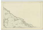
002 | [Situation] Flows west from the southern side of the plan and falles into the sea, 30 chains N.N.W. [North North West] of North Galson village. A river which flows out of Loch Sgeireach, and after a course of about five miles falls into the Sea at Gabhsunn O Tuath. It receives a number of tributaries, is not very rapid but contains a good quantity of water. |
| NORTH GALSON | Col. [Colonel] J. Farquharson C.B. R.E. [Royal Engineers] Director General Ord. [Ordnance] Survey Mr J Mathieson O.S. [Ordnance Survey] Edinburgh 1896 |
002 | ||
| GÀBHSUNN O' THUATH | Gàbhsunn O' Thuath or North Galson Gàbhsunn O' Thuath or North Galson Gàbhsunn O' Thuath or North Galson |
John Morrison John McKay Allan Ross |
002 | [On the Stornoway and Ness Road in the S.W. [South West] of the plan, 3 miles S.W. [South West] by W [West] of Dail O Dhais village. A small village of huts near the Sea Shore. They are built of stone and earth and thatched with straw. It is intersected by the Stornoway to Ness road and two other bye ones. It contains two slated houses, has a large tract of good arable, and a considerable portion of moorland attached to it. |
| NORTH GALSON RIVER | Col. [Colonel] J. Farquharson C.B. R.E. [Royal Engineers] Director Genl. [General] Ord. [Ordnance] Survey Mr J Mathieson O.S. [Ordnance Survey] Edinburgh |
002 |
Continued entries/extra info
[Page] 41Parish of Barvas
Transcribers who have contributed to this page.
Bizzy- Moderator, eilthireach
Location information for this page.