OS1/25/45/5


| List of names as written | Various modes of spelling | Authorities for spelling | Situation | Description remarks |
|---|---|---|---|---|
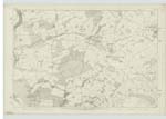
| ANNATY BURN | Annaty Burn Annaty Burn Annaty Burn |
J. Murray Graham Esq. Murrayshall Thomas Watson Parkside Stobies map of Perthshire |
086 | [Situation] Forming a portion of the NE. [North East] boundary of this district A Considerable Stream which rises in the eastern part of the Parish of Scone and flows in a S.W. [South West] direction by the Estate of Murrayshall - where it forms part of the Parish Boundary, - thence through the Village of Scone to where it empties into the River Tay at the North End of Bridgend near Perth. |
Continued entries/extra info
[Page] 5Parish of Kinnoull (detd. [detached] No.1) -- Sheet 86 No.14 Trace 6
Note
On this plan 86-14 the name extends no further North than the Mill Dam - & Bonhar Burn empties itself into this Dam - See page 6 AMS
Transcribers who have contributed to this page.
KinCF
Location information for this page.
Linked mapsheets.