OS1/24/38/21


| List of names as written | Various modes of spelling | Authorities for spelling | Situation | Description remarks |
|---|---|---|---|---|
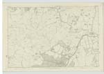
| TOR HILL | Tor Hill Tor Hill |
Revd. [Reverend] William Walkinshaw Lyne Manse John Hall, herd [shepherd] Torbank |
012 | [Situation] About ⅜ of a Mile NW. [North West] from Torbank. Thor - or as it is now corrupted to - Tor, is a high hill on Torbank farm - its surface is heathy - and on its Summit Stood two Camps - of a Circular Shape - the extent of which can be clearly defined. |
| TOR BURN | Tor Burn Tor Burn |
J. Hall Torbank J. Anderson W. [Wester] Happrew. |
012 | [Situation] West Side of Tor Hill. A small streamlet having its source on the west side of Tor Hill running in an Northerly direction till its conflux with the W [Wester] Happrew Burn near to the Main road. |
| TORBANK HILL | Torbank Hill Torbank Hill |
J. Hall Torbank J. Anderson W [Wester] Happrew |
012 | [Situation] About ½ Mile S.W. [South West] from Torbank. A hill of considerable height and extent on the farm of Torbank, its surface is heathy and on its summit stands a Trigl. [Trigonometrical] Station. |
Continued entries/extra info
[Page] 21Stobo Parish -- Sheet 12 .. 7. Trace 2.
Transcribers who have contributed to this page.
Alison James- Moderator, JOANMUIR
Location information for this page.
Linked mapsheets.