OS1/24/28/46


| List of names as written | Various modes of spelling | Authorities for spelling | Situation | Description remarks |
|---|---|---|---|---|
| BLACK RIG | Black Rig | A Anderson R Hamilton Shepherds |
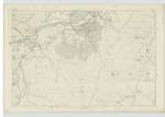
016 | [Situation] About ½ mile S.E. [South East] of The Scrape A Ridge of land on the far [farm] of Posso. and extending East Wards from the Case of Scrap [Scrape] to where the Berry Burn joins the Mill Burn. The Surface of which is Covered with Heathy Pasture. |
| BERRY BURN | Berry Burn | A. Anderson R. Hamilton |
016 | [Situation] Flows About ½ Mile E [East] of the Scrape A Small Stream which rises at the North Side of Black Rig and flowing in an Easterly direction till it joins the Mill Burn. |
| MILL BURN | Mill Burn | A.Anderson R.Hamilton |
016 | [Situation] Flows E [East] side of Black Rig A Stream which rises at the East Side of Broad Moss and flows in a N.E. [North East] direction till it joins the Mannor Water. To the South of Posso Farm house. |
Continued entries/extra info
[page] 46Parish of Mannor -- Sheet 16 No 11 -- Trace 2
Transcriber's notes
Words lost in fold of page.Transcribers who have contributed to this page.
Moira L- Moderator, eddlerose
Location information for this page.
Linked mapsheets.