OS1/11/62/13


| List of names as written | Various modes of spelling | Authorities for spelling | Situation | Description remarks |
|---|---|---|---|---|
| CAMP [Halltree] | Roman Camp Roman Camp Roman Camp Old Camp |
Map of farm William Johnston Walter Graham [Imrie's?] Map (Co) [County] |
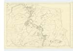
023 | [Situation] 11/2 mils [miles] of a mile W. [West] from CrooKston The remains of a Roman Campon the farm of Haltree it is nearly of an oval shape. formed with A Single Rampart of stones And earth. having two entrances or outlets on the east and west sides It is usually Called "the Roman Camp". altho' [although] there Cannot be any reason given for Calling [?]. |
| CAMP [Halltree] | Old Camp Old Camp Old Camp |
William Johnston Walter Graham Co. [County] Map. 1847 |
023 | [Situation] About 3/8 miles West by S [South] from CrooKston An old Camp on the farm of Halltree. Consisting of two ramparts of stones and earth, with a Fosse between them. The inner one is of an oval Shape and entire. while the outer is nearly taKen away and its form preserved by a Ring fence, The Camp is now Covered with Wood, |
Continued entries/extra info
Parish of Stow [Page] 13[Note] "There are remains of ancient Roman Camps on the farms "of Muirhouse, Stagehall, Craigend Watherstone Netheshiels "Perntaiton, and Hawtree, etc. They vary in Size from half an "acre as at Nethershiels to two acres as at Muirhouse and Craigend. "The larger ones are Circular while the others are oval. The Smaller "ones Seem to have been points of observation extending along the Strath"of the water for Communicating with one another by Signal." Stat. [Statistical] Acct [Account] of Edinb. [Edinburgh] Page 416
Transcribers who have contributed to this page.
Molly Miller
Location information for this page.
Linked mapsheets.