OS1/20/8/6


| List of names as written | Various modes of spelling | Authorities for spelling | Situation | Description remarks |
|---|---|---|---|---|
| BOW (Ruins of) | Bow (in ruins) Bow (in ruins) |
William McCrae James Sloan |
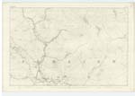
005 | [Situation] 7/8 mile, N.N.E [North North East] of Knockingarroch farm house The ruins of an old house on the farm of Waterhead and Situated a little west of Bow Burn. it had been occupied by herds when last inhabited. |
| BOW BURN | Bow Burn Bow Burn Bow Burn |
William McCrae James Sloan Ainslies Map 1820 |
005 | [Situation] Running S.[South] Westerly past Bow (in ruins) to its junction with the Water of Deugh A considerable stream or burn taking its rise on the farm of Knockingarroch, and running in a Southerly direction receiving numerous tributaries, to its confluence with the Water of Deugh. |
Continued entries/extra info
[Page] 6Parish of Carsphairn
Form 136 Page
25 Bow (Ruins of)
24 Bow Burn
Transcribers who have contributed to this page.
DANIALSAN, Gerald Cummins
Location information for this page.
Linked mapsheets.