OS1/20/55/63


| List of names as written | Various modes of spelling | Authorities for spelling | Situation | Description remarks |
|---|---|---|---|---|
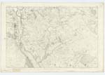
| CUBBOX ISLE | Cubbox Isle Cubbox Isle Cubbox Isle Cubbox CubbocKs |
William Candlish Esqr, John Muir Ainslies Map 1796 Val: [Valuation] Roll (1819) p: [page] 7 Ant [Ancient] Val: [Valuation] Roll (1819) p: [page] 6 |
024 | [Situation] About 3/4 miles E. [East] by S. [South] of New Galloway. - A Considerable portion of arable land lying on the Western Side of the Water of Ken &. on the farm of Cubbox (hence its name) It is more eminent than any of the circumjacent land. &. during floods it is visible when all around is completely deluged. The River, is said to have once ran round the Western Side of this enclosure, &. what is remarKable of the fact (is) that here the Parish of Balmaclellan Runs out of the Centre of the "Water of Ken." in a Westerly direction, Averaging about 7 or 8 chains for above 1/4 Mile, where it again runs into the river, what Seems to be the ancient Course of the river, is now quite Visible, in the Character of Marsh & Small pools. It is the property of John E. Spalding Esqr, of Holme house. The Parish Boundary is Shown here by little staKes visible from 1 to 2 feet. above the Surface of the ground |
Continued entries/extra info
Parish of Balmaclellan -- [Page] 63 -- Trace 4Form 136 Page
158 Cubbox Isle
Transcribers who have contributed to this page.
Molly Miller
Location information for this page.
Linked mapsheets.