OS1/20/54/4


| List of names as written | Various modes of spelling | Authorities for spelling | Situation | Description remarks |
|---|---|---|---|---|
| CRAIG GILBERT | Craig Gilbert Craig Gilbert Craig Gilbert Craig Gilbert |
William Folds John Muir Ph [Parish] Schoolmaster Robert KirK Ainslies Map - 1820 |
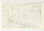
023 | [Situation] About 1/2 Mile South of Rig of Craig Gilbert. - A hill on the farm of Laggan of Dee the Surface of which is rocKy heathy pasture. On it is a Trigl. [Trigonometrical] Stati[on] Called by Trigl. [Trigonometrical] Party. BlacKcraig, This hill is joined to "Black Craig" by a Narrow Ridge called Rig of Craig Gilbert & forms part of the Same Range. . |
| LOWRING BURN | Lowring Burn Lowring Burn Lowring Burn Lowring Burn |
William Folds John Muir Ph. [Parish] Schoolmaster Kells Robert KirK William Thomson |
023 | [Situation] Running in a Southern direction from the base of BlacK Craig until it falls into the River Dee or BlacK Water of Dee . - A Small Stream or Burn taKing its rise at the base of BlacK Craig and running in a Southerly directio[n] to its influx with the BlacK Water of Dee. - |
Continued entries/extra info
[Page] 4 Parish of KellsForm 136 Page
30 - Craig Gilbert
30 - Lowring Burn
Transcriber's notes
Letters are lost in the gutter binding of both entries.Transcribers who have contributed to this page.
Molly Miller
Location information for this page.
Linked mapsheets.