OS1/20/51/16


| List of names as written | Various modes of spelling | Authorities for spelling | Situation | Description remarks |
|---|---|---|---|---|
| BACK BURN | BacK Burn BacK Burn |
Robert Taggart John Murray |
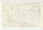
023 | [Situation] Running in a Southerly direction from the East Side of Carsgown Brae. A Small Stream or Burn taKing its rise on the lands of Craigenbay and Running in a Southerly direction to its influx with the River Dee. - |
| DEIL'S DIKE | Deils DiKe Deils DiKe |
William FoldS Nicholsons History of Galloway. Vol. [Volume] 1. Page 2. of the Appendix & Vol. [Volume] 1. Page 99. B | 023 | [Situation] Passing in a north easterly direction through Craigenbay MoSS &. across, the hill, Bennan & then inclines rather N. [North] westerly This old diKe or. (as it is generally thought) rampart is first visible issuing out of Loch Ryan in Wigtownshire. on the farm of Beach and traversing Galloway for about [30?] miles over hill & dale enters Dumfries. : Shire & joins the "Britton Wall" after which it runs into the Solway frith, Mr Train of C. [Castle] Douglas. (an antiquarian of Some note) traced it thro' [through] Galloway. He mentions that upon Some elevated spotS over which it passes RemainS of watch Towers are yet visible he also StateS that it is invariably 8 feet at the base & has a fosse at ita north or inland Side "This I find to be incorrect as regard the Portion of it which Passes thro [through] the farmS of Craignell. Craigenbay & on Plan 23 C. Mr Train is also in error in stating that it runs thro' [through] the farms of Craigencallie & Garrary as it Passes Some distance South of these farmS. It crosses the river Dee on the farm of Craignell. & is lost until it issues from the River further north in the character of an old Drain it then runs in a N. E. [North East] direction thro' [through] Craigenbay Moss; where it is again invisible for Some distance & then becomes discernable in the form of a dilapidated Stone fence & runs by the S. [South] Side of Craigenbay farm house & Passing over the E. [East] Side of Bennan (a hill on the farm of Upper Craigenbay) running in a N. W [North West] direction up that hill for a short distance, turns abruPtly (direct N [North]) & Runs into a Burn called Loch Spring Burn & hence on. Sometimes visible & SometimeS invisible During the remainder of its devious course thro' [through] the S. [South] of the Kingdom till its junction with the Solway frith, No mention has been made of this diKe by early Histor[ians?] Consequently its [origin?] or object is undecided. but it is generally thought to be a rampart of Defiance erected by the Aborgines against invaderS. the obscurity of its direction gives Rise to the name |
Continued entries/extra info
[Page] 16 Parish of KellsForm 136 Page
46 - Back Burn
50 - Deil's Dike
Transcribers who have contributed to this page.
Molly Miller
Location information for this page.
Linked mapsheets.