OS1/20/29/52


| List of names as written | Various modes of spelling | Authorities for spelling | Situation | Description remarks |
|---|---|---|---|---|
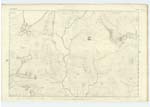
| BLACK GAIRY | Black Gairy Black Gairy |
John Murray n.s. Craigencallie via N. [New] Galloway A. McMillan n.s. Glenhead via Newton Stewart |
An extensive precipice on the western Side of 'Craignaw' It derives its name from its black appearance. | |
| CRAIGNAW | Craignaw Craignaw Craignaw |
John Murray n.s. Craigencallie via N. [New] Galloway A. McMillan n.s. Glenhead via N. [Newton] Stewart Ainslies Map |
014 | A considerable rocky heathy hill black and bare in the extreme its surface being a complete Mass of granite rocks Almost devoid of verdure On its Summit is a Trigl. ◬ [Trigonometrical Station] Called by Trigl. [Trigonometrical] Party 'Craigna Top.' |
| BRUSHIE BURN | Brushie Burn Brushie Burn |
John Murray n.s. Craigencallie via New Galloway A. McMillan n.s. Glenhead via Newton Stewart |
014 | A Small Stream having its source in Long 'Loch of the Dungeon' And flowing in a Southeasterly direction into 'Cooran Lane' |
Continued entries/extra info
[Page] 52List of Names collected by Samuel Barclay Laborer
Plan 14A Trace 5
Parish Minnigaff
Object
Black Gairy - a precipice
Craignaw - a hill
Brushie Burn - a Stream
[Signed] Samuel Barclay
14th. Sept. [September] 1849
Transcribers who have contributed to this page.
Chr1smac -Moderator, DANIALSAN
Location information for this page.
Linked mapsheets.