OS1/20/19/34


| List of names as written | Various modes of spelling | Authorities for spelling | Situation | Description remarks |
|---|---|---|---|---|
| CHAPEL LINN | Chapel Linn Chapel Linn |
William Alexander Thomas McKie |
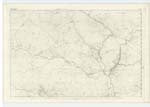
009 | [Situation] 3/4 Mile N.E. by E. [North East by East] of Glenhowl A cascade or waterfall of about 15 feet high on the "Black Water" and situated about 12 Chains East of "Black Water Bridge" how it got its name is not known in the locality. |
| BLACK WATER | Black Water Black Water Black Water |
William Alexander Esqr. Thomas McKie Ainslies Map. 1820 |
009 | [Situation] Running W. [West] to its junction with the Water of Ken A considerable stream or burn having its rise out of Loch Trostan, and running in a Westerly direction passing thro' [through] "Black Water Bridge" from which to its conflux with the Water of Ken, it sides are very precipitous and afforded some hiding places for the persecuted presbyterians, during the period of the persecutions in the 17 century. |
Continued entries/extra info
[Page] 34Parish of Dalry
Left hand side of page Form 136 Page 81 Chapel Linn; 76 Black Water
Transcribers who have contributed to this page.
Gerald Cummins
Location information for this page.
Linked mapsheets.