OS1/20/151/183


| List of names as written | Various modes of spelling | Authorities for spelling | Situation | Description remarks |
|---|---|---|---|---|
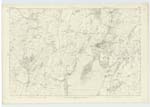
| Sypland Moat | Sypland Moat | Williamson Meikle Sypland John Nicholson Kirkcudbright John Broom Kirkcudbright Alexander Kinner Kirkcudbright Statistical Acct [Account] of County |
050 | A tolerable sized Fort situated on the summit of a considerable hill on the farm of Meikle Sypland, at its base it measures about 140 feet in diameter and tapers a little to its summit which is about 120 feet in diameter. It os surrounded on all sides but the East by a pretty entire fosse and ramparts on the East it is defended by a considerable abrupt declivity of about 130 feet in depth. Although this fortress is invariably called a Moat by the people of its locality , but by the persons that is aquainted with such would call it a Fort. The later is the nearest. Its summit commands an extensive prospect of the surrounding Country, the Mountain ranges of Minnigaff, Kells & Carsphairn, the Borrowhead, Mull of Galloway The Isle of Man the Mountain ranges of Cumberland the Estuary of the Dee, and a wide expanse of the Irish Sea Also on a clear day the far famed Mountains of Morn in Irland can be brought into its view. |
Continued entries/extra info
[Page] 183List of Names collected by David Hannay C Asst [Civilian Assistant] 6th June 1849
Plan 50D
[Signed] D Hannay
C. Asst [Civilian Assistant]
Transcribers who have contributed to this page.
Skinnb1- Moderator
Location information for this page.
Linked mapsheets.