OS1/20/103/10


| List of names as written | Various modes of spelling | Authorities for spelling | Situation | Description remarks |
|---|---|---|---|---|
| RIG OF DRUMRUCK | Rig of Drumruck Rig of Drumruck Rig of Drumruck Rig of Drumruck Drumruck Drumruk |
John Brown Esqr John Gardener Samuel McLelland Esqr. Gatehouse Map of Property valuation roll 1819 valuation roll ancient |
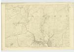
037 | [Situation] 5/8 mile W [West] by S. [South] of Burnfoot (in ruins). A Hill of a ridge like shape [upon] the farms of Murrowton & [Meikle] Cullendoch & is now on the [extinct] farm of Drumruck [from] which it takes its name. The property of Horatio [Grandvile] Stewart Murray Esqr. of [Cally]. |
| CAIRN TAMMOCK | Cairn Tammoch Cairn Tammoch Cairn Tammoch Cairny Tannoch Cairn Tammock |
John Gardener John Ferguson John Brown Esqr. Map of Property see Name List Plan 37A |
037 | [Situation] 7/8 mile nearly W. [West] by S [South] of Burnfoot (in ruins). A small oval eminence on summit of the rig of [Drumruck.] On it is a Trigl. [Trigonometrical] Station called [by] Trigl. [Trigonometrical] Party "Drumruck". |
| WHITE BRAE | White Brae White Brae White Brae |
John Ferguson John Gardener John Denniston Gatehouse |
037 | [Situation] 3/8 mile WSW [West South West] of Burnfoot (in ruins). An enclosure near the Base [or the ] Rig of Drumruck the surface of [which] is rocky heathy pasture, and [appears] Whitish at a distance hence [its] name. On the farm of [Murrowton] |
Continued entries/extra info
[Page] 10 -- Parish of GirthonForm 136
Page 28 - Rig of Drumruck
Page 27 - Cairn Tammock
Page 29 - White Brae
[Note] Tammock. A hillock
Jamieson Scottish Dicty [Dictionary]
Transcribers who have contributed to this page.
Chr1smac -Moderator, raschdorff
Location information for this page.
Linked mapsheets.