OS1/14/74/3


| List of names as written | Various modes of spelling | Authorities for spelling | Situation | Description remarks |
|---|---|---|---|---|
| NEWTYLE [parish] | Newtyle Ph. [Parish] | Sheriff's List of Meresmen New Stat. Acct. [Statistical Account] Johnston's Co. [County] map Old Stat. Acct. [Statistical Account] Fullarton's Gazetteer Oliver & Boyd's Amanack Valn. [Valuation] Roll of County |
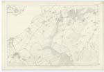
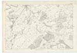
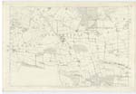
042; 043; 048; 049 | [Situation] In the SW. [South West] end of Forfarshire. A parish at the South-west verge of Forfarshire, quadrangular in form and presenting its angles nearly to the Cardinal points. It measures about 2½ miles by about two, and its area as computed from ordnance plans is 5194.828 Imperial acres. - It is bounded on the north-west by Perthshire, on the North and NE [North East] by Eassie and Nevay, on the east by Glammis and part of Auchterhouse, on the south by Auchterhouse and by Lundie and Fowlis and on the SW. [South West] by Kettins. The surface runs up on the SE. [South East] and on over half of the adjacent sides to a water shedding line of the Sidlaw hills and declining north westward it settles down into a pendicle of the level ground of Strathmore. The chief heights are Kinpurney on the NE. [North East] boundary, Newtyle Hill on the SW. [South West] boundary and Hatton Hill about midway between them. Newtyle is in the presbytery of Meigle and Synod of Angus and Mearns, Patron Lord Wharncliff. There is no detached portion of Newtyle, nor is there any detached portion of any other parish within that of Newtyle. |
Continued entries/extra info
[Page] 3Parish of Newtyle
Transcribers who have contributed to this page.
Alison James- Moderator, KBMW- Moderator
Location information for this page.