OS1/14/70/119


| List of names as written | Various modes of spelling | Authorities for spelling | Situation | Description remarks |
|---|---|---|---|---|
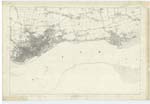
| MONIFIETH SANDS | Monifieth Sands Monifieth Sands Monifieth Sands Sands of Monifieth |
Revd. [Reverend] Mr. Young James Webster James Low Chart of Frith of Tay 1816 |
054; 055 | [Situation] Along the southern side of the parish A large extend of sands forming the foreshore of Monifieth parish and stretching from almost opposite Bent Ho. [House] to the eastern boundary of the Ph. [Parish] - they are interspersed with numerous patches of boulders & shingle. Near Milton, the foreshore at low water extends a considerable distance into the Tay, forming a bank or bar, named "Lady Bank" |
| MONIFIETH LINKS | Monifieth Links Monifieth Links Monifieth Links |
Revd. [Reverend] Mr. Young James Webster James Low |
055 | [Situation] Along the south side of the parish. These links are situated at the south side of the parish, contiguous to the H.W. [High Water] mark, and stretch along the foreshore for a considerable distance. They are defined on the east by the parish boundary, on the south by H.W. [High Water] mark, and terminate on the west near to Broughty Ferry opposite Bent House - the northern limit is defined on traces by yellow dots. These links are wholly Rough pasture, interspersed with furze |
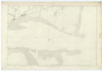
| FIRTH OF TAY | Firth of Tay | See Name Sheets for plans of Fife and Kinross |
Continued entries/extra info
[Page] 119Sheet 55 No.2.
Transcribers who have contributed to this page.
Alison James- Moderator, Ian Downie
Location information for this page.