OS1/14/38/1


| List of names as written | Various modes of spelling | Authorities for spelling | Situation | Description remarks |
|---|---|---|---|---|
| DUNNICHEN [parish] | Dunnichen | Gazetteer of Scotland Oliver & Boyd's Almanac Walker's Map of Scotland |
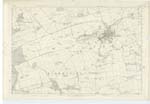
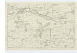
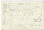
038; 039; 045 | [Situation] Towards the South East of Forfarshire. The name of this Parish is supposed to consist of Gaelic Dun a hill and Nechtan the name of a Pictish Chief who is traditionally reported to have lived in the district. The vernacular is Dunnachen. The Parish of Dunnichen is bounded on the North by those of Forfar and Rescobie on the East by Rescobie Kirkden and Carmylie, on the South by Guthrie (DETd) [Detached] and on the West by Inverarity and Forfar. Part of it too is quite detached which is bounded by Kirkden Parish except on the S.E. [South East] where Carmylie adjoins or bounds it. The respective Areas of the two parts are 4094 and 828¾ acres making a total Area of 4922¾ acres. The surface in general consists of gently sloping ridges and is considerably high but does not shoot up into any very great elevations. Dunnichen Hill [continued on page 2] |
Continued entries/extra info
[Page] 1Parish of Dunnichen -- County of Forfar.
Transcribers who have contributed to this page.
Alison James- Moderator, Caspell
Location information for this page.