OS1/14/17/27


| List of names as written | Various modes of spelling | Authorities for spelling | Situation | Description remarks |
|---|---|---|---|---|
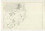
| MONTROSE BASIN | Montrose Basin | See Craig Parish | 035 | See N.[Name] Sheet of Craig. The Basin at Low Water in this Parish is generally a mixture of Mud & Sand, having towards the landward side a good deal of gravel sprinkled over it, which makes it much firmer or harder than the parts described on Traces as Mud & Sand. There is mud at one or two places, & Mussel Beds between the South Esk & the Old Dyke known as the Dronner's Dyke. The Mussel Beds are sometimes shifted. Montrose Basin is commonly called "Back Sands" by the people from being the Sands &c. at the back of the Town & Harbour. |
| DRONNER'S DYKE | Dronner's Dyke Dronner's Dyke Dronner's Dyke Dronner's Dyke Dronner's Dyke Drainers or Dronners Dyke |
Mr. Webster Tide Surveyor Mr. Murray Customs Officer Mr. Miller Fisherman Mr. Myers, Town Clerk Montrose Mr. Burgess Writer Montrose Memorials of Angus & Mearns |
035 | "Slezer's view of the town says there was a jetty or harbour in the Basin of the South Esk near the Forthill (in Montrose). Such may have been the case but the long piled erection shewn in that engraving as stretching across the Basin from the back of Forthill, is clearly the Drainers or Dronner's Dyke which was [continued on page 28] |
Continued entries/extra info
[Page] 27Co. [County] Forfar -- Parish of Dun
Transcribers who have contributed to this page.
Alison James- Moderator, Alice Bremner
Location information for this page.
Linked mapsheets.