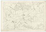
OS1/13/15/35


| List of names as written | Various modes of spelling | Authorities for spelling | Situation | Description remarks |
|---|---|---|---|---|
| CONLAND BURN | Conland Burn Conland Burn Conland Burn |
William Inglis, West Conland John Inglis Mid Conland Robert Barclay Drums |
017 | This burn rises in the East Lomonds flows east by the Conlands, from which it receives its name, and falls into the Leven Water. |
| FORMOUNT HILLS | Formount Hills Formount Hills Formount Hills |
John McCrae Formount Hill William Inglis West Conland John Inglis Mid Conland |
017 | This is a small height between the farms of West Conland and Formount Hill, to the latter giving its name. It is partly arable; and is let along with farm to Mr John Macrae by the proprietor Lord Rothes. On it is a Trig [Trigonometrical] station called Forman Hill. From its rugged and uneven surface it presents the appearance of a number of hills. |
Continued entries/extra info
page 35Parish of Leslie Plan 17C Trace 5
Conland Burn situation -- About 2 1/8 Miles S.W. [Southwest] of the Village of Fruchie.
Formount Hills situation -- About 2 1/8 Miles S.W. [Southwest] of the Village of Fruchie.
Transcribers who have contributed to this page.
MaxInSpain , Jill S
Location information for this page.
Linked mapsheets.