OS1/15/44/23


| List of names as written | Various modes of spelling | Authorities for spelling | Situation | Description remarks |
|---|---|---|---|---|
| WHITELAW HILL | Whitelaw Hill Whitelaw Hill Whitelaw Hill Whitelaw Hill White Law Hill |
County Map (Forrest's) Mr. Dawson F. Walker Thomas Renwick Johnston's Map |
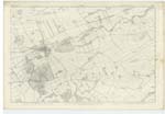
010 | [situation] About 1 1/8 Miles S E by E [South East by East] of the parish church of Morham. An elevated portion of land on the farm of Whitelaw situated a little North of Whitelaw Dam head. |
| WHITELAW DAM HEAD | Whitelaw Dam Head Whitelaw Dam Head Whitelaw Dam Head Whitelaw Ham Head |
Co. [County] Map Mr. Dawson Mr. Walker Thomas Renwick |
010 | [situation] About 1 1/2 miles S E by S. [South East by South] of the parish church of Morham. A small pond from which there is a Small Stream running in an easterly direction having no name, and a mill race running from it to Whitelaw farm house |
| Dunstane Plantation | Dunstane Plantation | See Name Book Plan 11C | [situation] About 1 1/4 miles E by S. [East by South] of the parish church of Morham. Descriptive Remarks in Name Book. Plan 11 C |
Continued entries/extra info
Parish of Whittingham [page] 23[Page] 43 Whitelaw Hill
43 Whitelaw Dam Head
Dunstane Plantation
Transcribers who have contributed to this page.
Chr1smac -Moderator, VickiColeman
Location information for this page.
Linked mapsheets.